1999 would have been a year that is celebrated by the residents of the area in and around the 6th Milestone of Bukit Timah. It was in August of that year when the Singapore Turf Club (STC) moved its race course from its sprawling 140 ha. site off Dunearn Road north to the site of the current race course at Kranji, bringing much relief to the area’s long suffering residents.

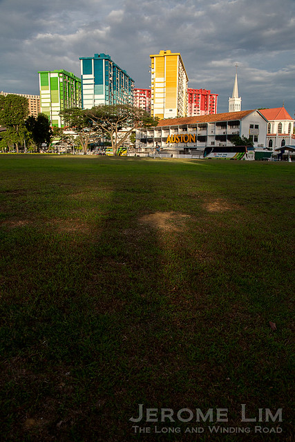
The old and new grandstands of the former Bukit Timah Race Course as seen today.
Opened on 15 April 1933 by the then Governor of Singapore, Sir Cecil Clementi, who made his grand entrance riding in on the back of a horse; the race course was to experience its first race day traffic holdup at its inaugural race meeting in May of the same year. Described as “Saturdays Great Hold Up” in a 22 May 1933 report in the Singapore Free Press and Mercantile Advertiser, a motorist spoke of the 25 minutes it took him to cover the final mile into the car park, which was said to be almost three times as long as the time he had taken to cover the distance from town to the new race course.

A post card of the then newly built new Race Course with its iconic 5000 seat grandstand.
That the 1933 opening was a grand occasion, there is little doubt. Among the 5000 guests at the opening was the Sultan and Sultanah of Johor, the Tunku Mahkota, as well as the Sultan of Perak – who was at the time the largest individual owner of racehorses in Malaya.

The original south grandstand as seen today.
The new course, designed by Swan and MacLaren, was itself built as a replacement for the older race course at what is today Farrer Park. The older race course’s location in the city made it difficult for it to be expanded and a decision was taken in 1927 to sell off the site, the use of which went back to the Singapore Turf Club’s founding as the Singapore Sporting Club in 1842, to the Singapore Improvement Trust. A new site was identified and the 244 acres (99 ha.) acquired from the Bukit Timah Rubber Estate for it in 1929 required the felling of some 25,000 of the estate’s rubber trees and a huge effort in the levelling of the area’s undulating terrain. The new race course’s location also made it convenient to move racehorses around to the other venues in the Straits Racing Association’s circuit in the Peninsula by rail with the re-sited Bukit Timah Railway Station of the 1932 railway deviation located just a stone’s throw away.

A view of the former south grandstand from the car park.

A reminder of its horsey past.
Among the features of the new race course and its spread of structures such as stables and quarters was its rather iconic grandstand with its distinctive central clock tower. The three tier grandstand at its opening contained a royal box and press box on its second level and stewards’ and owners’ boxes on the upper tier. The stand was also fitted out with some 2000 tip-up teak chairs, which was described as “the largest single chair order East of the Suez”.

A track-side view of the former South Grandstand.
One thing that the Turf Club, renamed in 1924 as the Singapore Turf Club, wasn’t able to do was to commemorate its centenary with war interrupting the running of races from Octber 1941 to November 1947. The days leading up to the fall of Singapore saw the British Military move in and during the occupation the race course and its auxiliary buildings were reportedly used as a prisoner of war camp and its lawns used for growing food crops.

The area where the former race track was – now used as a sports ground.
Much of the appearance that the former race course’s main structures display today, are the result of work carried out to expand its capacity in the 1970s and 1980s. A second grandstand, the North Grandstand, which expanded the seating capacity to 8,000 and a possible 50,000 standing, was added in 1981. The two-storey car park we still see on the grounds today, was an addition made at the end of the 1980s. Another addition made, a multi-storey car park with a capacity of 2900 cars at the corner of Swiss Club Road and Dunearn Road, has however since been demolished.

The north grandstand, which came up in the early 1980s.

The upper deck of the two-storey car park that was added at the end of the 1980s.
The grounds, zoned in the Urban Redevelopment Authority’s Master Plan for future residential use, was soon after the race course’s last meeting in July 1999, re-purposed in part for use as Turf City. Among the tenants during an initial ten-year period and the extension of its lease to 2012, were a hypermarket, dining outlets, early education providers and other retail outlets in the former grandstands as well used car dealers on the ground level of the spacious double-storey car park. During this time the building took on a rather worn and tired look.

The link way between the car park and the former grandstand.

A touch of the countryside nearby at the Bukit Timah Saddle Club – which has been using part of the race course’s estate since 1951.
Under a new leasee, the former grandstands and car park has been refurbished and reopened as The Grandstand in 2012. Besides the hypermarket and used car dealers from the Turf City days, The Grandstand has also attracted a host of dining outlets and a new-age food hall style market. This is however, only in the interim as under the terms of the new lease, even if some S$20 million has been pumped into the refurbishment, will see it used for a maximum of 3 + 3 years, after which the race course and its long association with Bukit Timah, will possibly only be a distant memory,

As Turf City – seen in early 2012.

Another look at the inside of the South Grandstand in its Turf City days.

The last days of Turf City.

Other parts of the former race course site such as the former stables at 100 Turf Club Road have also been re-purposed – this as HorseCity.

A residence belonging formerly to the Turf Club, which remains vacant.
Filed under: Architecture, Bukit Timah Area, Changing Landscapes, Forgotten Buildings, Forgotten Places, Reminders of Yesterday, Singapore


 During a recent visit to the mosque, I learnt that curious sounding Kampong Jantai, was actually a transliteration of the name of a Chinese village, Gian Thye, which the area had also been home to. The occupants of Kampong Jantai, were apparently largely of Boyanese (or Baweanese) descent, and included a certain Haji Buang Masadin, who was instrumental in obtaining the plot of land to build the mosque. Haji Buang, who took the name Haji Mashhor after embarking on the Hajj, also lent his name to the road,


/Waterloo%20Street%20No%20155%20Former%20Stamford%20Girls%20School/Waterloo%20Street%20155/WaterlooSt%20155FcdArc1972001URA.jpg?as=0&h=500&w=700&bc=FFFFFF)